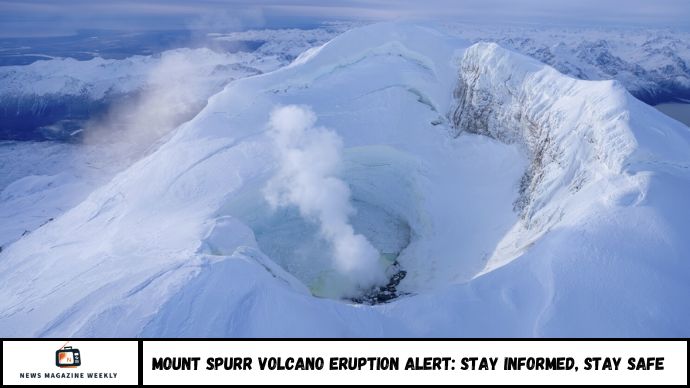
Alaska’s Mount Spurr is showing signs of renewed volcanic activity, with elevated seismicity, increased gas emissions, and past ground deformation indicating that an eruption could be approaching. This article explores the current warning signs, what they mean, and how residents and travelers can stay informed and safe.
Signs of trouble are rising beneath Mount Spurr and they’re getting harder to ignore. Volcanic gas emissions have surged, earthquake activity is above normal, and the ground itself has shifted. These are the classic warning signs of a volcano under pressure, and right now, Mount Spurr in southcentral Alaska is showing all three.
Located about 80 miles west of Anchorage, Mount Spurr is the tallest volcano in the Aleutian Arc — and it’s restless. According to the Alaska Volcano Observatory, the mountain has shown “significantly elevated” volcanic gas emissions, alongside increased seismicity and surface deformation. In a March 2025 update, experts warned these signals suggest that an eruption is possible within weeks or months.
So what does this mean for Alaska — and what exactly could happen if Mount Spurr erupts again? Let’s break down the latest science, what to expect, and how to prepare.
Is an Eruption at Mount Spurr Likely?
With over 3,400 earthquakes recorded beneath the surface in early 2025, Alaska’s Mount Spurr is officially in a phase of unrest. While not all volcanic activity leads to an eruption, the signs seen today—including increased sulfur gas emissions and previous ground inflation—suggest the volcano is charging up.
But how close are we really to an eruption? What can we expect next? This article unpacks the current signs, past eruption history, and what you need to know to understand the situation.
Key Signs Mount Spurr Is Waking Up
1. Increased Seismic Activity
The most significant indicator of unrest has been a steady rise in earthquakes:
- Thousands of small quakes have occurred beneath the volcano’s summit and its active vent, Crater Peak.
- Most quakes have been shallow, meaning magma is likely moving closer to the surface.
- The volume and frequency of quakes, while slightly reduced in recent months, remain higher than normal background levels.
Why this matters: Earthquake swarms often precede volcanic eruptions, especially when combined with other indicators.
2. Elevated Volcanic Gas Emissions
Gas sensors have recorded a sharp increase in volcanic gases:
- Sulfur dioxide (SO₂) emissions have risen more than eightfold compared to late 2024.
- Carbon dioxide (CO₂) emissions also remain elevated.
- These gases typically escape from magma underground, indicating upward movement and pressure buildup.
Why this matters: An increase in gas output can signal that magma is nearing the surface and that an eruption may occur if the pressure is not released gradually.
3. Recent Ground Deformation
Earlier this year, GPS monitoring detected:
- Ground uplift measuring between 2.4 and 6 centimeters.
- Inflation centered approximately 3 to 5 kilometers beneath the volcano.
Although this uplift has since paused, it signals that magma had moved into shallow areas beneath Mount Spurr’s surface.
Why this matters: Ground deformation is often one of the final warning signs before eruption, showing that magma is accumulating underground.
4. Current Volcano Alert Level
The Alaska Volcano Observatory has assigned:
- Alert Level: Advisory
- Aviation Color Code: Yellow
This status means the volcano is more active than normal but not yet erupting. The level could rise quickly if new changes occur.
What Could Happen If Mount Spurr Erupts?
Mount Spurr has erupted before—and explosively. The most recent eruption in 1992 sent ash plumes over 12 miles into the air, closing airports and disrupting air traffic across Alaska and parts of Canada.
Likely eruption hazards include:
- Ashfall that could affect nearby communities and air travel
- Fast-moving pyroclastic flows near Crater Peak
- Lahars (volcanic mudflows) from melting snow and ice
- Short-term but dangerous gas exposure near the summit
How Scientists Monitor Mount Spurr
Monitoring includes:
- Seismometers to detect earthquakes
- Gas sensors to measure SO₂ and CO₂ emissions
- GPS instruments and satellite radar to track ground movement
- Webcams and satellite images to detect visual changes
- Infrasound sensors and lightning detectors to track explosive activity in real time
This data helps scientists detect changes quickly and alert authorities, pilots, and the public in advance.
FAQs
1. Is Mount Spurr erupting now?
No, but it is experiencing unrest with elevated earthquake activity and gas emissions.
2. How dangerous is Mount Spurr’s unrest?
The danger is moderate at present, but it could increase rapidly if signs intensify.
3. What would an eruption look like?
Most likely, it would be explosive with significant ash plumes and local hazards near Crater Peak.
4. Will we get a warning before it erupts?
Typically yes. Increased seismic activity, more gas emissions, and renewed uplift would likely appear before an eruption.
5. Has Mount Spurr erupted before?
Yes, most recently in 1992. That eruption caused air traffic disruptions and heavy ashfall.
6. What’s the volcano’s current status?
It’s at Alert Level “Advisory” and Aviation Color Code “Yellow”—higher than normal, but not yet erupting.
Conclusion
While Mount Spurr isn’t erupting yet, the signs of unrest are significant enough to watch closely. The combination of earthquakes, gas emissions, and past deformation points to a volcano that is building pressure. Whether this activity leads to an eruption in the near future is uncertain, but being informed is the best way to stay safe.

